Ancient Civilizations.png


"The generally accepted history of humanity is based upon a progression that begins with early hominids developing “stone age” tools, then advancing on with an increasing capacity to hunt animals and establish agricultural practices and other technologies that established civilization in our early history. What if this story is incomplete? What if there is evidence of a more ancient and far more advanced civilization that perhaps had access to technologies that could accomplish feats that even today we can only dream of?”

- The Resonance Academy

Art-mayan-civilization-city-pyramid-palm.jpg


Wall-Texture-Vector-Background-1170604697_6000x3495.jpeg
 

Although we’ve discovered evidence modern humans lived on this planet for more that 200,000 years, we know virtually nothing about any of them beyond about 6,000 years. What remains from these monolithic civilizations are stone buildings that are engineering marvels, even by modern standards. Who were they? How did they accomplish such amazing things?

As author the inquisitor Graham Hancock observed:


 We are a species with amnesia.

Temple-Ruins-In-The-Jungle,-Near-Angkor-Wat-In-Cambodia-891658046_3008x2000.jpeg


Contemplate vast empires that rose and fell nearly without a trace; see mummified remains in North America that are approximately 11,500 years old; and consider the baffling technological implications of stone architecture created many thousand of years ago ... in Egypt, Mezoamerica, the Pacific Islands, Europe and other surprising locations.

Around the world, we can find numerous examples of ancient stone-cutting so precise that they rival creations of the modern day produced with advanced machinery.  But one of the most impressive examples can be found at Puma Punku, an ancient archaeological site in Bolivia – dated by some historians to be 17,000-years-old – that contains such incredible stonework that it looks as if the stones were cut using a diamond tool.  Enormous blocks weighing up to 800 tons, consist of perfectly straight edges that lock perfectly into each other and contain no chisel marks. Attempts to replicate the precision of the stonework have failed and archaeologists, as well as stone masons, are at a loss to explain how they accomplished such precise cuts without advanced technology.

The human timeline continues to reach further and further back in time.  Consider the archaeological breadcrumbs of human occupation in Northern Australia around 65,000 years ago.  From the treasure trove of human teeth discovered in China to human remains in the middle east (Israel ChinaMorocco) - we have evidence of civilizations ranging from 80,000 350,000 years ago.  In Europe, meticulously crafted statuettes date back to the Paleolithic era - that is 2.6 million years ago.

de85jnd-9c931a3f-5c16-4619-8f0e-ce7cb74bfcbf.jpg
 
Ancient_Lost to Time.png

"Lost to time" is an idiomatic expression which means that something is no longer known or remembered, it has been forgotten over time. It can refer to events, ideas, people, or things that were once known or important but are now no longer remembered or recorded. It's a way of saying that something has fallen into oblivion and is no longer accessible to us. It can also imply that something was so long ago that it is unlikely to be recovered.


lg_f081547662a2-nubta-playa.jpg

Nabta Playa

Almost 500 miles from Cairo, this civilization farmed, created ceramic vessels,a nd domesticated animals more than 9,000 years ago.  Stone circles resembling Stonehenge are mysteriously present - suggesting they studied astronomy, among other things.

 
lg_c27915fb7680-catalhoyuk.jpg

Çatalhöyük

Considered by some to be one of the first urban settlements in the world, this ancient city in modern-day Turkey is in some ways most notable for its unusual architecture. Built without streets as we know them, the city was instead a sort of honeycomb of buildings, all connected together. The inhabitants used the rooftops to travel, and climbed down ladders to access their dwellings. Instead of having communal cemeteries, residents buried their dead beneath the floors of their homes. While it is theorized that the city's residents spread out into the rest of the region, its unique architecture and culture seems to have never been reproduced.


Derinkuyu

Not as old as Catalhoyuk, perhaps, but equally unusual is the underground city of Derinkuyu.  Derinkuyu is also located in what is now Turkey. Though it is not the only underground city in the region, it is one of the most extensive, reaching its greatest size sometime between the years 500 and 1000 CE. The underground city consisted of tunnels and rooms cut into the soft rock of the region, extending down for as much as 5 stories and housing 20,000 people as well as livestock at its peak. The subterranean city once offered respite from nearby enemies, even after it was used as a residence. It was fully abandoned in 1923, not to be reopened to the public until 1969.

 
lg_12ff7d720a16-easter-island-wikimedia-cc22.jpg

Easter Island

Famous for its moai, the large stone statues that are virtually synonymous with its name, Easter Island is also known as Rapa Nui and was once home to a thriving and industrious, if not particularly large, population. By the time European explorers discovered the 63 square mile island, the population had declined dramatically, likely as a result of over-harvesting of the local palm trees. Whatever the actual reason, the origins and decline of Easter Island and its unique culture and statues have retained a lasting fascination ever since. 


Cahokia

Americans tend to think of lost civilizations as being the purview of explorers of far distant lands, but many can be found closer to home. There are lost civilizations waiting just beneath the surface of even America's heartland. Just across the Mississippi river from St. Louis, Cahokia was once the largest known city in North America. Consisting of almost a hundred earthen mounds, many of which can still be visited today, as well as a huge central plaza, the city's inhabitants are known to have diverted the flow of the Mississippi river. No one knows why they abandoned the city around 1200 AD. Some researchers believe that two significant floods could have contributed to its decline and abandonment. 


Foothills Mountain 

The civilization that we call "Anasazi" left behind incredible pueblo cities cut into the cities of cliffs throughout the American Southwest, known now as the Foothills Mountain Complex. What they did not leave behind was a reason for their decline, or even their actual name. The name "Anasazi" comes from Navajo and means ancient enemies. Many contemporary descendants of this ancient civilization prefer the term Ancestral Puebloans. Whatever they were called, the Ancestral Puebloans once built great cities across the areas of Utah, Arizona, New Mexico, and Colorado, but by the end of the 13th century, the cities were largely abandoned. Popular theories about the decline of the Puebloans include drought, famine, war, and, of course, something to do with aliens. 


Angkor

Today, Angkor Wat is one of the most famous and immediately recognizable ruins in the world. However, Angkor Wat was once simply part of a larger city, Angkor. The enormous temple complex—the largest religious monument on earth, occupying some 402 acres—was once a part of a metropolis larger than modern-day New York City. Angkor was the capital of the Khmer Empire. The city flourished during much of the Khmer rule, but fell into ruin 300 years before the end of the empire. While there are plenty of explanations for why the city may have slipped into ruin, what we still don't understand is the full extent of its original scope, or just how many people may have lived there at its height.


Thonis, Egypt

A scene of a scuba diver exploring a massive Egyptian statue may seem like something from the upcoming Tom Cruise Mummy movie, but it's actually archaeologists attempting to piece together the history of the city of Thonis. Once the gateway to Egypt, Thonis is now on the bottom of the Mediterranean Sea. Like the fabled city of Atlantis, Thonis sank beneath the waves. No one is quite certain why, though today archaeologists are attempting to excavate the remains of the sunken city. 


lg_54679c0d91b4-chichen-itza-mayan-ruins-copy.png

The Maya

When we think of crumbled empires whose ultimate fates remain unknown to us, one of the first names to come to mind is that of the Mayan Empire. The Mayans once occupied the entire Yucatan Peninsula in what is today Mexico, Guatemala, and Belize. While the Mayan language is still spoken today throughout Mexico and Central America, the great civilization fell into decline before the arrival of European settlers to the region, and no one is certain why. 


Black-Grunge-Background-Dirty-Concrete-Wall-Stucco-Vintage-Rock-Texture-Ombre-Dark-Stone-1145467657_5464x4096.jpeg

 The Antikythera Mechanism

NAMA_Machine_d'Anticythère_1.jpg

1. IT WAS FOUND IN A ROMAN-ERA SHIPWRECK AND NAMED AFTER A GREEK ISLAND.

Located in the Aegean Sea between mainland Greece and Crete, Antikythera is an island that literally means “opposite of Kythera,” another, much larger island. The ship is assumed to be Roman and, when it sank just off the coast of the island in the middle of the 1st century BCE, carried a huge number of artifacts dating back to as early as the 4th century BCE.

2. THE FIRST EXPLORATION OF THE WRECK KILLED ONE DIVER AND PARALYZED TWO OTHERS.

In 1900, Greek sponge divers found the shipwreck, which was submerged nearly 150 feet, while wearing gear that was standard for the early 20th century—canvas suits and copper helmets. When the original diver surfaced with reports of artifacts, horses, and corpses, the captain assumed he had “raptures of the deep”—essentially, a drunkenness as a result of the nitrogen in the breathing mix piped into the diving helmet. Although that diver was actually fine, later exploration in the summer of 1901 caused the death of one diver and the paralysis of two more from decompression sickness or "the bends.”

3. THREE IMPORTANT ROMANS MAY HAVE BEEN INVOLVED.

An astrophysicist at Athens University, Xenophon Moussas, theorized in 2006 that the boat on which the mechanism was found may have been headed to Rome as part of a triumphal parade for the emperor Julius Caesar in the 1st century BCE. A related theory is that the ship was carrying booty from the Roman general Sulla’s sack of Athens in 87–86 BCE. In the same time period, the famous Roman orator Marcus Tullius Cicero mentioned a mechanical planetarium called a “sphere of Archimedes” that demonstrated how the Sun, Moon, and planets moved with respect to the Earth. More recent research, though, suggests that the ship may have been en route to Rome from Turkey. The ship’s path has been difficult to trace because the Aegean was an important and busy shipping area at this time.

4. THE MECHANISM'S IMPORTANCE WASN'T RECOGNIZED FOR 75 YEARS.

The unique bronze-and-wood object was found with a shipload of marble, coins, glassware, and pottery in 1900. Since all the other artifacts were more apparently worthy of conservation, the mechanism was ignored until 1951. After an additional two decades of study, the first publication on the Antikythera mechanism was made in 1974 by physicist and historian Derek de Solla Price. But Price’s work was unfinished when he died in 1983, without having figured out how the device actually worked.

5. JACQUES COUSTEAU AND RICHARD FEYNMAN WERE BOTH FASCINATED BY IT.

The famous marine explorer Jacques Cousteau and his team dived the Antikythera shipwreck in 1976, shortly after Price’s primary publication, finding coins from the 1st century BCE and a few smaller bronze pieces of the mechanism. A few years later, noted physicist Richard Feynman visited the National Museum in Athens. Feynman reportedly was terribly unimpressed by the museum as a whole, but wrote that the Antikythera mechanism was “so entirely different and strange that it is nearly impossible … it is some kind of machine with gear trains, very much like the inside of a modern wind-up alarm clock.”

6. IT'S BEEN CALLED THE WORLD'S FIRST COMPUTER.

Since long before the invention of the digital computer you are undoubtedly reading this on, there have been analog computers. These types of computers range from mechanical aids like a slide rule to a device that can predict the tides. The Antikythera mechanism, which was designed to calculate dates and predict astronomical phenomena, has therefore been called the earliest analog computer.

7. THE INVENTOR OF TRIGONOMETRY MAY HAVE ALSO CREATED THE MECHANISM.

Hipparchus is primarily known as an ancient astronomer; he was born in what is now Turkey around 190 BCE and worked and taught primarily on the island of Rhodes. His works survive almost entirely through later Greek and Roman authors. Hipparchus was one of the first thinkers to speculate that the Earth revolved around the Sun, but he could never prove it. Hipparchus created the first trigonometric table in his attempts to solve problems related to spheres, and is therefore known as the father of trigonometry. Because of these other discoveries—and because Cicero mentions a planetary device that was constructed by Posidonius, who took over Hipparchus’s school on Rhodes after his death—the Antikythera mechanism is often attributed to Hipparchus. New research, though, has shown handwriting of two different people on the mechanism, suggesting it was likely created in a workshop or family business.

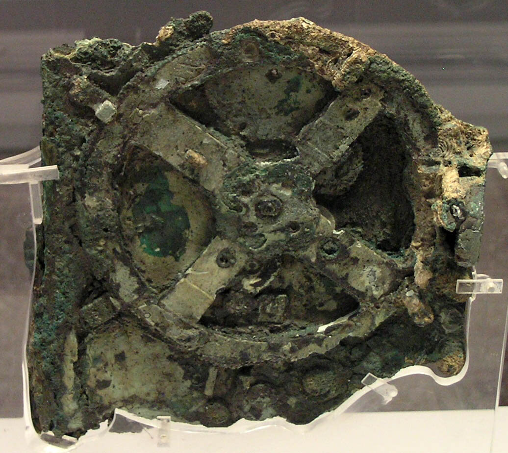
8. IT WAS SO TECHNOLOGICALLY ADVANCED, NOTHING SURPASSED IT FOR CLOSE TO 1500 YEARS.

Consisting of at least 30 bronze gears in a wooden container that was only the size of a shoebox, the clockwork mechanism was highly advanced for its time. By turning a hand-crank, the user could move forward or backward in time. The crank made the gears move and rotate a series of dials and rings on which there are inscriptions and annotations of Greek zodiac signs and Egyptian calendar days. It seems that the information to build such a mechanism was lost through time, perhaps because it was a specialty device or expensive to create. Similar astronomical clocks didn’t reappear in Europe until the 14th century. Since inventions like this do not usually come from nothing, though, many researchers think that we may yet find older precursors in an archaeological context some day.

9. IT WAS DESIGNED TO MONITOR CELESTIAL EVENTS, SEASONS, AND FESTIVALS.

The mechanism tracked the lunar calendar, predicted eclipses, and charted the position and phase of the Moon. It also tracked the seasons and ancient festivals like the Olympics. The calendar is based on the time from one full moon to the next, and a special dial allowed the user to also envision the seasons, which would have been useful for agriculture. Since the ancient Babylonians figured out the cycle of eclipses, the inventor of the Antikythera mechanism included two dials that rotate to show both lunar and solar eclipses. But the most sophisticated thing the mechanism did was lunar calculations—it could figure out the Moon’s period at a given time and model its elliptical orbit.

10. IT HAS A BUILT-IN INSTRUCTION MANUAL.

Writing on a bronze panel at the back of the mechanism suggests the inventor left either instructions for how to work it or an explanation of what the user was seeing. The inscription, which is in Koine Greek (the most common form of the ancient language), mentions the cycles, dials, and some of the functions of the mechanism. While the text doesn’t specifically tell someone how to use it, and assumes some amount of prior knowledge of astronomy, it provides written-out labels for the person looking at the mechanism.

11. NO ONE IS SURE WHO USED THE MECHANISM …

While many of its functions have been figured out, how and where it was used are still unknown. Scholars think that it could have been employed in a temple or school, but could just as easily have been a fancy curio for a rich family. Without any other comparable artifacts or explanatory inscriptions, we don’t yet know who would have used this object or to what end.

12. …BUT THEY'RE CLOSING IN ON WHERE IT WAS MADE.

The use of Koine in the numerous inscriptions places the creation of the mechanism in the Greek world, which was geographically large at the time. The festival dial mentions the Olympics in central Greece, the Naa in northwest Greece, and the Halieia on the island of Rhodes. The latest analysis of the inscriptions, reported this week by classicist Alexander Jones and colleagues, suggests the mechanism could keep track of at least 42 different calendar events. With those dates in mind, Jones and colleagues calculate that the creator of the mechanism was likely based at 35°N latitude. Coupled with Cicero’s mention of a similar device at Posidonius’s school, this means that the island of Rhodes is again the leading contender for the origin of the mechanism.

13. THE DEVICE ALSO TOLD FORTUNES.

Jones and colleagues’ new interpretation of the mechanism is based on the extant 3400 Greek characters on the device, although thousands more characters are likely missing due to the incomplete nature of the artifact. Most notably, in their thorough linguistic analysis, these scholars discovered that the mechanism refers to eclipses’ color, size, and associated winds. The Greeks believed that characteristics of an eclipse were related to good and bad omens. Because of this belief, by building in predictive eclipse technology, the creator of the mechanism was letting the user divine the future.

14. PLANETARY MOTION IN THE MECHANISM WAS ACCURATE TO WITHIN ONE DEGREE IN 500 YEARS.

The mechanism includes hands or pointers for Mercury, Venus, Mars, Jupiter, and Saturn, all of which are easily visible in the sky, as well as a rotating ball that showed the phases of the Moon. The parts that work these planetary pointers are gone, but text on the front plate of the mechanism confirms, according to Jones and his team, that the planetary motion was modeled mathematically using numerous complex gears—and that it was highly accurate.

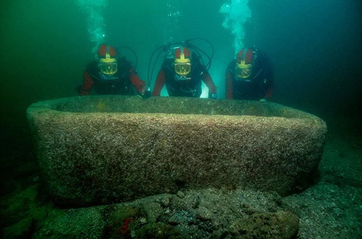
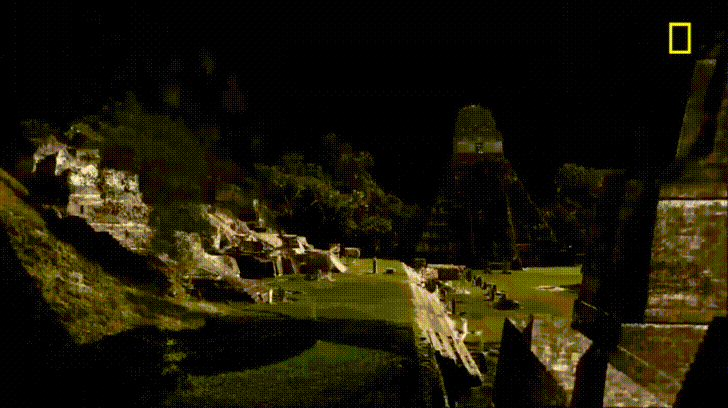
15. THERE MAY ACTUALLY BE TWO ANTIKYTHERA SHIPWRECKS.

Since Cousteau explored in the mid-1970s, little work has been done at the underwater archaeological site because of the remote location and the depth of the water. In 2012, marine archaeologists from the Woods Hole Oceanographic Institute and the Hellenic Ephorate of Underwater Antiquities again dove the wreck with the latest, high-tech scuba gear. They found a massive spread of amphorae and other artifacts. This means that either the Roman ship was vastly larger than previously thought or there is a separate wreck down there. Excavations have been ongoing for several years, with new artifacts brought up constantly. Summer 2016 is poised to reveal even more about the Antikythera shipwreck. You can follow along in real time via the Woods Hole website and blog.


 “This I have actually seen, a work beyond words. For if anyone put together the buildings of the Greeks and display of their labours, they would seem lesser in both effort and expense to this labyrinth… Even the pyramids are beyond words, and each was equal to many and mighty works of the Greeks. Yet the labyrinth surpasses even the pyramids.”

These are the words of ancient Greek historian Herodotus written in the 5th century BC (‘Histories’, Book, II, 148), describing a colossal temple said to contain 3,000 rooms full of hieroglyphs and paintings. It was named ‘Labyrinth’ by the Greeks after the complex maze of corridors designed by Daedalus for King Minos of Crete, where the legendary Minotaur dwelt. Yet today, nothing remains of this supposedly grand temple complex – at least not on the surface.

https://www.wisegeek.com/what-are-the-seven-wonders-of-the-ancient-world.htm#

3qz93m2UMunMwXGFrAyF6d-970-80.jpg
Ancient-Egyptian-Statue-168264784_3537x2000.jpeg


ee9b7385c0b153d5b5c3f17914752076.jpg

stone-wall-texture-854608548_6720x4480.jpeg


Göbekli Tepe is an archaeological site located in the Southeastern Anatolia Region of Turkey. It is believed to be one of the oldest known religious structures in the world, with the oldest parts of the site dating back to around 11,000 BCE. The site consists of a series of circular and oval-shaped enclosures, containing massive T-shaped pillars that are decorated with carvings of animals and other symbols. Many of these pillars are up to 20 feet tall and weigh up to 20 tons.

The site was discovered in the 1960s by local shepherds, but it wasn't until the 1990s that a team of German archaeologists began excavating the site in earnest. Since then, Göbekli Tepe has been the subject of intense scholarly interest, and it has been proposed as a possible location for the biblical Garden of Eden.

Research has suggested that the site may have been used for a variety of religious or ceremonial purposes, and that it was likely constructed by a group of hunter-gatherers rather than by a settled agricultural society. The site is considered a monumental architecture and it required a organized effort and resources from the society.

The significance of Göbekli Tepe is that it is challenging the previously held assumption that agriculture and settled lifestyle came before monumental architecture and complex societies.

What others have to say about Göbekli Tepe:

What skeptics have to say:


Golbeki.png

Ancient.png


NightSky_Stars_Black & White 0142.jpg

Stonehenge


Stonehenge is a prehistoric monument located in Wiltshire, England that is composed of a ring of standing stones. The most interesting and mysterious aspects of Stonehenge include:

  • Its construction, which is believed to have taken place in several stages over a period of about 1,500 years. The stones were brought from as far away as 150 miles, and how prehistoric people transported these massive stones is still not fully understood.

  • Its purpose, which is not known for certain. Many theories have been proposed, including that it was a place of religious worship, a healing center, or a astronomical observatory.

  • The presence of graves dating to the Bronze Age within the stone circle has led to speculation that Stonehenge may have served as a cemetery or a place to bury important leaders.

Similar discoveries of stonehenge-like structures around the world include:

  • The standing stones at Carnac in Brittany, France, which have been dated to around 4500 BC

  • The standing stones at Callanish in the Outer Hebrides of Scotland, which have been dated to around 2900 BC

  • The standing stones at Ha'amonga 'a Maui in Tonga, which are believed to have been erected around 1200 AD

There are many theories about similar structures around the world, but most experts believe that they were built for ceremonial or religious purposes. Some theories suggest that they may have been used as astronomical observatories or to mark the passing of the seasons. Other theories propose that they served as places of religious worship or were built to commemorate important events or leaders.

SeekPng.com_runes-png_1335236.png


grunge-surface-171349161_3750x2658.jpeg


Controversial author and inquisitor, Graham Hancock, asks important questions as he uncovers interesting breadcrumbs of human civilization.

GIANT HUMANS


There have been claims that giant skeletons have been found in New Mexico, but there is no scientific evidence to support these claims. Many of these claims are based on hoaxes or misunderstandings of the remains of normal-sized humans or other animals. Some people may misidentify normal human bones as those of giants due to lack of knowledge or experience in identifying human remains. In addition, many of these claims are based on unverified or fraudulent reports that lack any supporting documentation or scientific analysis. In summary, there is no credible evidence that giant skeletons have been found in New Mexico or anywhere else.


vintage-paper-with-space-for-text-or-image-1136737651_3700x2457.jpeg

Immersive Technologies

As this project is released in 2020, we’ll be integrating emerging technologies

to help you more richly explore various concepts.

The Technology of Archaeology

Modern advances in technology help us see and understand the world around us in new and startling ways.  Here are some of the most recent techniques used to help understand our world's history.


LIDAR IMAGING

dAmRlW2_-_Imgur.gif

Lidar stands for Light Detection and Ranging.(also called LIDARLiDAR, and LADAR) is a surveying method that measures distance to a target by illuminating the target with pulsed laser light and measuring the reflected pulses with a sensor. Differences in laser return times and wavelengths can then be used to make digital 3-D representations of the target. 

GOOGLE EARTH

Satellite imagery such as Google EarthMicrosoft’s Bing and Nasa’s World Wind has made it possible to zoom into even the most remote corners of the globe to locate sites. By helping to spot things like settlement mounds or enclosures, it can help draw attention to places where such sites may be found. Aerial photographs have been used in this way since the 1930s, but these were typically difficult to access. The universal availability of Google Earth has therefore made it a fantastic tool for professional and citizen scientists alike. However there are many pitfalls in interpretation of satellite images that can only be resolved on the ground.


SOIL GEOCHEMISTRY

Traces of faeces from both humans and animals around ancient settlements can stay in the soil for millennia. It has long been known that by recording patterns of heavy metals in the soil, it may be possible to locate these ancient sites. This is especially important if there are little or no artefacts left behind. One way to carry out such measurements is by collecting samples and analysing them in the lab. But in the last few years, portable X-ray fluorescence spectroscopy measurers (pXRF) have become available, enabling rapid in-the-field recording of samples. They work by emitting X-rays that the atoms of the sample absorb. This boosts the energy of the atoms, which in response emit secondary x-rays at a unique energy that reveals the elements the sample is made of.

GROUND PENETRATING RADAR

Tank-Animation-1.gif

When ground penetrating radar, which uses radar pulses to image the ground, was first applied to archaeology in the early 1980s, it was believed to be the answer to many problems in archaeology. But while the technology gradually improved, archaeologists were not impressed. The early use of such radar produced sections through the deposits. However, there were endless cases of false positives. Recently, software has come to the rescue of the technology, by allowing three-dimensional modelling, making visualisation much more reliable. One advantage of ground penetrating radar is that it works in confined spaces and through hard surfaces. But interpreting the results remains a problem. Be very sceptical of hidden Egyptian tombs and Nazi trains.


MAGNETOMETERS

jtzwftc5-1410529783.jpg

Magnetometry is the technique of measuring and mapping patterns of magnetism in the soil. Ancient activity, particularly burning, leaves magnetic traces that show up even today when detected with the right equipment. Buried features such as ditches or pits, when they are filled with burnt or partly burnt materials, can show up clearly and give us an image of sub-surface archaeology. 


SATELLITE IMAGERY

lightning-storm-from-space-gifgif.gif

When archaeologists want to find lost monuments or hidden cities these days, they turn to satellite imagery. Patterns invisible to the eye on the ground become obvious from the air and help scientists decide where they should start digging. And now you can join those scientists by signing up for GlobalXplorer, a newly launched online community where members look at real satellite imagery from Peru to identify telltale patterns of ancient habitation.


AERIAL IMAGERY

ER2.gif.gif

Aerial photos allow archaeologists to identify patterns, such as earthworks, crop marks, and soil marks, that may indicate the presence of archaeological sites. It can be used to locate and document sites, map and monitor sites and landscapes, and identify potential threats to sites, such as urban expansion or looting.

Aerial photography can also be used in combination with other techniques, such as ground-penetrating radar and lidar (light detection and ranging), to create detailed and accurate maps of sites and landscapes. This information can be used to understand the spatial organization and distribution of features within a site, and to inform the design and implementation of fieldwork projects.


SHALLOW GEOPHYSICS

screen-record.gif

Geophysical techniques can help locate targets to investigate. Soil resitivity for example is a measure of how much the soil resists the flow of electricity. It can uncover differences in soil moisture to reveal buried structures and can reliably range up to around 1.5 metres in depth. However it is slow, as probes have to be inserted into the ground at regular intervals, but it can produce highly detailed results. Magnetometery measures the intensity of the earth’s magnetic field. This can reflect the pattern of archaeological features created through either burning, or by soil bacteria that can leave magnetic traces in the soil. It is a fast technique, and has proven especially good for desert sites, such as in ancient Egypt. Recently, sensitive magnetometers with multiple sensors, mounted on a cart and linked to GPS, are capable of surveying many hectares in real-time a day and revealing entire landscapes, such as those around Stonehenge.

black-wall-texture-2-693317332_6000x4000.jpeg


Cuban Underwater City

In 2001, a team of scientists and engineers led by Paulina Zelitsky discovered an underwater city near the coast of western Cuba using sonar technology. The site, which is known as the "City of Cuba," appears to have been a large, man-made structure that may have been built thousands of years ago. The team found what appeared to be pyramids, roads, and other man-made structures. The site is believed to be one of the oldest and largest underwater cities in the world. However, the evidence is not conclusive, and there is ongoing debate about the nature and origins of the structures. Some experts have suggested that they are natural formations or the remains of more recent structures, rather than an ancient city. More research would be needed to confirm whether an underwater ancient city truly exists near Cuba.

https://en.wikipedia.org/wiki/Cuban_underwater_city

Sonar images interpreted as being symmetrical and geometric stone structures resembling an urban complex were first recorded in early 2001 covering an area of 2 square kilometres (200 ha)[citation needed] at depths of between 600 metres (2,000 ft) and 750 metres (2,460 ft).[1] The discovery was reported by Pauline Zalitzki, a marine engineer, and her husband Paul Weinzweig, owners of a Canadian company called Advanced Digital Communications,[4] working on an exploration and survey mission in conjunction with the Cuban government. The team returned to the site a second time with an underwater remotely operated vehicle that filmed sonar images interpreted as various pyramids and circular structures made out of massive, smooth blocks of stone that resembled hewn granite. Zalitzki said "It's a really wonderful structure which really looks like it could have been a large urban centre. However, it would be totally irresponsible to say what it was before we have evidence."[1]

After studying the images, National Geographic senior editor John Echave said: "They are interesting anomalies, but that's as much as anyone can say right now, but I'm no expert on sonar and until we are able to actually go down there and see, it will be difficult to characterize them."[5] Professor of oceanography Robert Ballard was quoted as saying: "That's too deep. I'd be surprised if it was human. You have to ask yourself: how did it get there? I've looked at a lot of sonar images in my life, and it can be sort of like looking at an ink blot -- people can sometimes see what they want to see. I'll just wait for a bit more data."[5]

Marine geologist Manuel Iturralde called for more samples before drawing conclusions about the site, saying the results so far were very unusual. He estimated that it would have taken 50,000 years for such structures to have sunken to the depth at which they were said to be found and stated that none of the known cultures living that long ago had the ability to build such structures. A specialist in underwater archaeology at Florida State University added: "It would be cool if they were right, but it would be real advanced for anything we would see in the New World for that time frame. The structures are out of time and out of place."[4]

Underwater_.png